All Hikes
View all Arizona hikes → PhoenixSedonaTucsonFlagstaff Grand CanyonSaguaroPetrified ForestSuperstition Wilderness

View all Utah hikes → MoabSt. GeorgeSalt Lake City ZionBryce CanyonArchesCanyonlands

View all Colorado hikes → Denver AreaColorado SpringsTelluride Rocky Mountain NPMesa VerdeBlack Canyon

View all California hikes → Eastern SierraSan DiegoBay Area Joshua TreeYosemiteDeath ValleySequoia

View all New Mexico hikes → AlbuquerqueSanta FeTaos White SandsCarlsbad CavernsSandia Mountains

About

Flatiron via Siphon Draw Trail

A legitimate day hike that starts easy, passes through one of the more dramatic basins in the Superstitions, and ends with class 3 scrambling up to a plateau that looks like it was designed to be looked at from below.

5.51 mi.Distance
+3,438 ft.Elevation
5.0 - 7.5 hrs.Est. time
6.6/10Our Rating
YesDogs
$7 day use fee (state park — America the Beautiful pass not accepted)Fees

Our Ratings

How we rate trails

🏔️
Scenery Views, landscape variety, and visual payoff. Does the trail deliver something worth the effort?
🥾
Trail Quality Surface condition, signage, and how well-maintained the route is. A high score means you can focus on the hike instead of the logistics.
🌿
Solitude Crowd levels and the realistic chance of finding a quiet moment. One of the most honest scores we give — popular trails pay for their scenery here.
🚗
Accessibility Parking, trailhead amenities, and how easy the trail is to access for someone visiting the area for the first time.
🦅
Wildlife & Nature Flora, fauna, and ecological interest beyond the view. Trails with rich desert or alpine ecosystems score well here.

Each category rated 1–10. Overall score is the average.

🏔️ Scenery
9
🥾 Trail Quality
6
🌿 Solitude
4
🚗 Accessibility
8
🦅 Wildlife & Nature
6
Overall Score 6.6/10

Difficulty

How we score difficulty

Scored from elevation gain per mile and technical terrain. A trail with scrambling or route-finding gets a higher score than pure grade alone. Hard trails are not necessarily better trails.

1-2 Very Easy Flat, short, well-maintained
3-4 Moderate Some elevation, clear trail
5-6 Challenging Sustained climb, rough surface
7-8 Strenuous Steep, technical, some exposure
9-10 Extreme Scrambling, route-finding, serious commitment
7 /10
Strenuous

Steep, technical, some exposure

Getting There

Flatiron via Siphon Draw Trail Trailhead

There is a shape visible from the eastern Phoenix Valley that looks exactly like what it is called. It sits at the top of the Superstition Mountains, flat on top and steep on every side, and from the right angle in the right light it looks like something left up there deliberately. Getting to it is a full day’s work. The trail up is not a trail for most of its upper half. It is a climb.

Overview

Flatiron via Siphon Draw is an out-and-back that starts in Lost Dutchman State Park, passes through a wide open rock basin, and ends on a plateau at 4,860 feet that offers views of the entire Phoenix Valley and the surrounding Superstition range. It is considered one of the harder day hikes in the Phoenix area. The first two miles are accessible to anyone in reasonable shape. Above the Basin, the trail becomes class 3 scrambling and stays that way to the top. It is not suitable for beginners.

Three Hikes Stacked on Top of Each Other

The Flatiron experience changes completely three times and it helps to know what you are walking into.

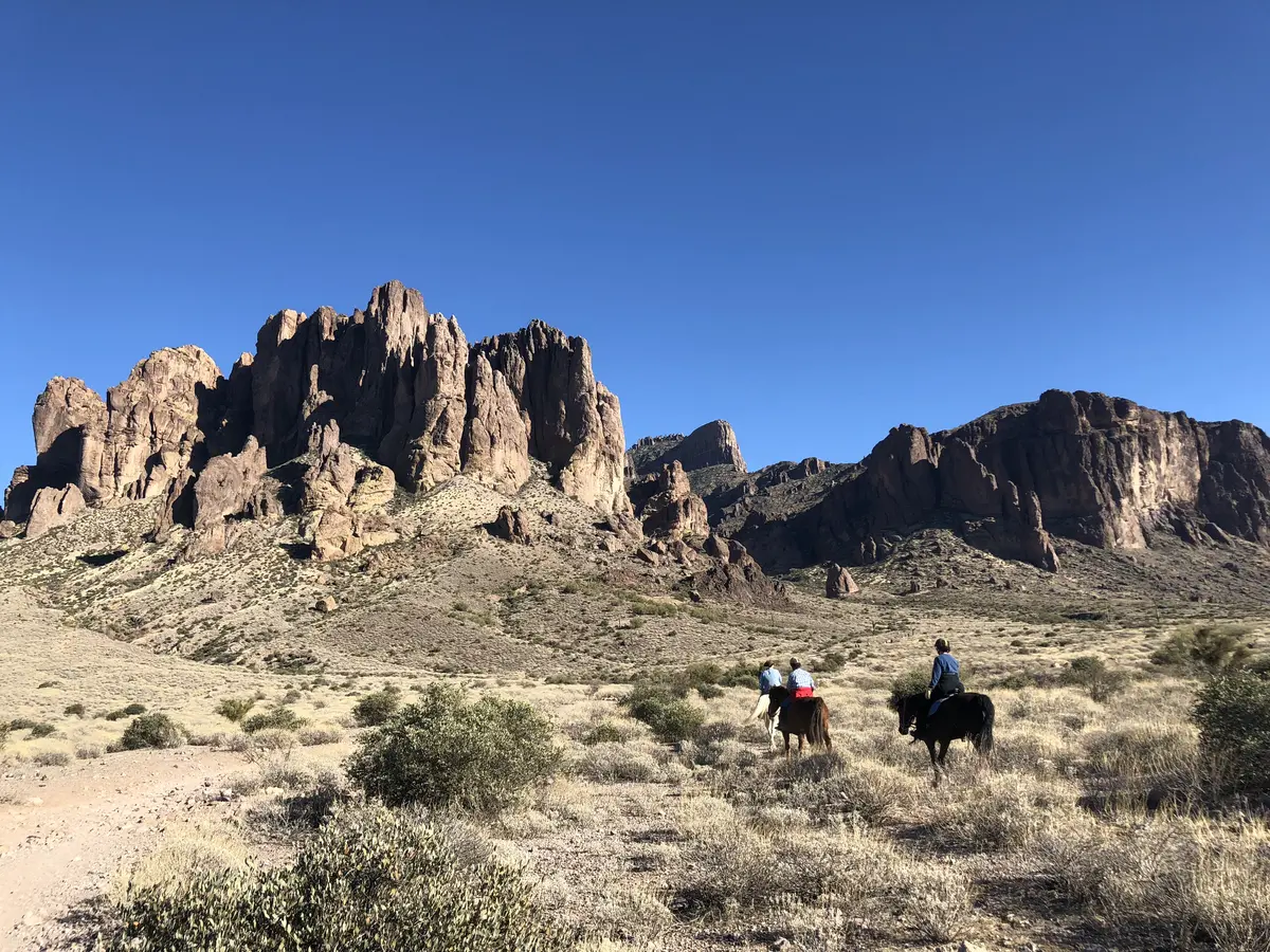
The first section, from the Lost Dutchman trailhead through the lower trail to the edge of the Basin, is straightforward desert hiking. The path is well maintained and clearly defined. You move through saguaro forest, past the park campsites, and into the Tonto National Forest boundary. The grade is consistent but not punishing. This section moves quickly and gives a false sense of what is ahead.

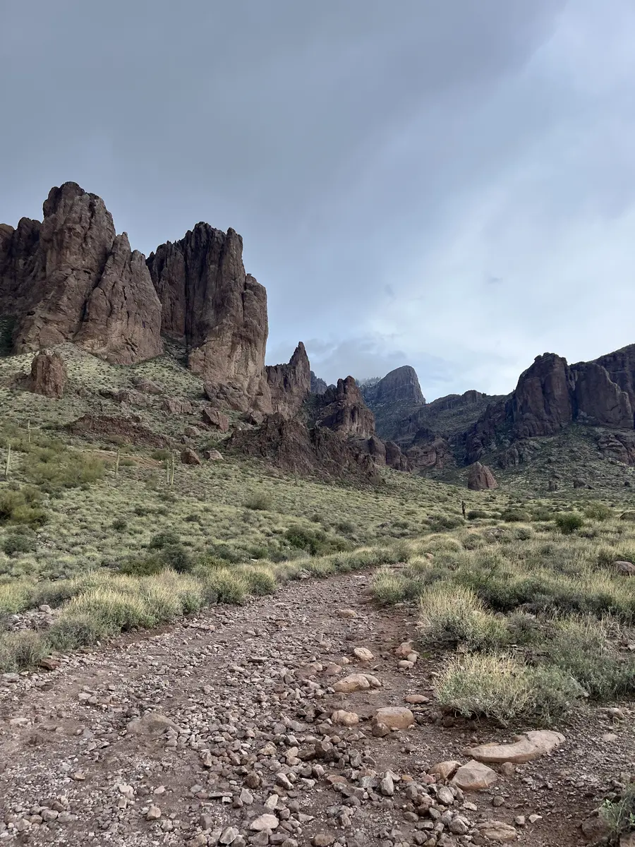
The Basin is where things get interesting. It is a broad, smooth expanse of volcanic rock sitting in a natural bowl in the mountains. During wetter months a small stream runs through the middle of it. The rock is slick in places, the grade starts to increase, and the views behind you of the desert below are already worth the trip. This is also the last obvious landmark before the route becomes ambiguous. A lot of hikers stop here. That is a reasonable decision.

Above the Basin the trail dissolves. What replaces it is steep, exposed slickrock and boulders painted intermittently with blue and white markers. The markers help but they do not eliminate the route-finding. You are climbing now, not hiking. Hands go on rock. The grade is severe and sustained. The exposure is real and the consequences of a slip are significant. This section is where the hike earns its reputation.

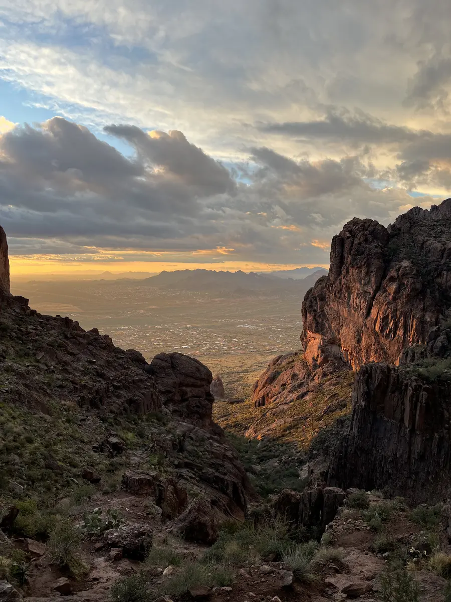
The Flatiron itself, once you pull up onto the plateau, is wide and flat and almost surreal after what it took to get there. The views run in every direction: the Valley spread out to the west, Canyon Lake to the south, the ridgeline of the Superstitions stretching east. It is a good place to sit for a while before heading back down, because the descent above the Basin requires the same focus as the ascent.

Timing & Crowds

November through April. The hike is long enough that summer is not viable even with an early start, and it has a documented history of rescues during hot months. The best conditions are November through February when temperatures are cool and the light on the rock is good all morning.

Start early regardless of season. The upper section is exposed and faces the sun directly. A pre-dawn start in peak season is not excessive. Even in December, being on the upper section before 9am is significantly more comfortable than pushing into midday.

Crowd levels are moderate by Phoenix standards. This trail sees real traffic on weekends in season but it is not Camelback. The lower trail and Basin sections are the busiest. Above the Basin the numbers thin out considerably. Weekday visits in December or January are genuinely quiet on the upper mountain.

Getting There

Lost Dutchman State Park is located on State Route 88 east of Apache Junction, about thirty minutes from central Phoenix. The park entrance is clearly signed from the highway. The Siphon Draw Trailhead is inside the park with a proper parking area and clean restrooms.

The day use fee is $7 per vehicle. America the Beautiful passes are not accepted here because this is a state park, not federal land. No additional permits are required.

What to Bring & Safety

Water first. Three liters is a reasonable starting point for a cool day. The hike is long and the upper section is exposed and strenuous. More is better. There are no water sources on trail.

Footwear matters significantly above the Basin. The rock is slick and steep, and grip is the difference between a manageable scramble and a dangerous one. Trail runners with aggressive tread work. Approach shoes or stiff-soled hiking boots work better. Sandals and casual sneakers are a bad idea and you will see people in them struggling.

The upper section has meaningful exposure. If you are not comfortable with heights or with trusting your footing on steep slick rock, the Basin is the right turnaround point. There is no shame in it and the views from there are real.

Tell someone where you are going and when you expect to be back. Carry a fully charged phone. This trail has a history of rescues and the upper section has limited cell service.

Weather at Trailhead

Loading conditions...
Trail Map

Route shown is approximate and for illustration only. Not for navigation.

Elevation Profile

Nearby Hikes

Battleship Mountain
2.6 mi away
Picketpost Mountain Trail
21.8 mi away

How It Compares

TrailDistanceElev. GainDifficultyRatingDogs
Flatiron via Siphon Draw Trail5.51 mi.+3,438 ft.7/10 6.6/10Yes
Picketpost Mountain Trail4.62 mi.+2,608 ft.8/10 7.2/10Yes
Battleship Mountain12.16 mi.+3,027 ft.7/10 6.4/10No

Virtual Flyover

Virtual Flyover
5.51 mi +3438 ft

Route shown is approximate and for illustration only. Not for navigation.

Frequently Asked Questions

How hard is the Flatiron hike really?
Harder than most people expect going in. The first couple of miles are a gradual incline through pleasant desert terrain. The basin looks deceptively manageable. Above the basin the trail becomes class 3 scrambling, meaning hands and feet on steep slick rock with significant exposure. It takes most fit hikers four to seven hours round trip. Do not underestimate the upper section.
What is the Basin and is it worth going to if you don't summit?
The Basin is a broad, smooth rock area roughly two miles in and it is a legitimate destination on its own. It offers good views, a natural rest point, and during wetter months a small seasonal stream runs through it. If you have kids, dogs with limited scrambling experience, or want a shorter day, the Basin and back is a solid three to four mile option.
Are dogs allowed on the Flatiron hike?
Technically yes, but the upper section above the Basin involves steep boulder scrambling that many dogs cannot handle safely. If your dog is experienced with technical terrain and has solid footing on slick rock, it can be done. If not, the Basin is a better turnaround point for them.
Can I use my America the Beautiful pass at Lost Dutchman State Park?
No. Lost Dutchman is an Arizona State Park, not a federal land, so the America the Beautiful pass does not apply. The day use fee is $7 per vehicle.
What time should I start the Flatiron hike?
Early morning. The trail has almost no shade and the upper scrambling section faces the sun directly. In peak season, starting at or before sunrise gives you the best conditions and the most comfortable temperatures. The hike takes long enough that a late start in any season except deep winter creates real heat exposure on the descent.
Is the Flatiron hike harder than Camelback Mountain?
They are different kinds of hard. Camelback is steeper and more sustained but shorter. Flatiron is longer with a more gradual approach, but the upper section is more technical and the overall day is significantly longer. Most experienced hikers put Flatiron in a higher difficulty category simply because of the time and technical commitment involved.
Can you hike Flatiron in summer?
No. This is one of the few Phoenix-area hikes where even an early start does not make summer viable. The trail is long enough that you cannot complete it before the heat builds, and people have been rescued from this mountain multiple times during hot months. November through April is the window.